
Hello Friends,
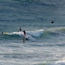
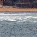
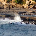
We had a light SW breeze for the early risers this morning. It was chopping lots of places up and generally maintaining yesterday afternoon’s so-so surface conditions. Huey’s turned the power setting down on the two metre SE swell. It’s now around the 7 second mark, so yesterday’s average wave is more like today’s average set. At North Narrabeen and Dee Why centre, the waves were mostly in the waist high and smaller range before 0700. There are still the occasional bigger sets but the incoming tide was making them look pretty weak and flabby.
The good news is that the wind won’t be getting much stronger according to the Bureau. And the swell, such as it is, ought to keep bumping along at more or less the same energy levels this morning as it gradually declines over the next couple days.
We’re heading into a week (at least) of fairly average conditions with large dollops of onshore and small dollops of swell energy. A few days ago it seemed that we might have a pulse for Friday, but the models seem to have gone cold on the idea and are instead showing a slight uptick on Sunday. If they have it right this time, the conditions should be roughly similar (in terms of size and energy levels) to yesterday.
Speaking of which, I got out and about with a camera yesterday and will shortly be posting a couple fresh galleries to my collection. In the morning I did some shooting at Manly (between North and South Steyne mostly) and later in the afternoon I grabbed some more snaps of the hot groms warming up for Pro Junior. Very junky conditions, but some impressive surfing nonetheless.
Have yourself a top old day!
TIDES: H @0920 and L @1600
Weather Situation
A slow-moving high pressure system is centred west of Tasmania and a weak ridge extends along the New South Wales coast. The high will move east of Tasmania on Thursday as the low currently over the eastern Tasman Sea approaches New Zealand. The high will move further away during Friday and Saturday but still maintain a ridge over the New South Wales coast.
Forecast for Thursday until midnightWinds: South to southeasterly 10 to 20 knots. Seas: Up to 2 metres. Swell: Easterly 1.5 metres. Isolated thunderstorms offshore during the day.
Forecast for FridayWinds: Southeasterly 5 to 10 knots tending east to northeasterly 10 to 15 knots by early evening. Seas: Below 1 metre. Swell: Southeasterly 1.5 metres tending easterly about 1.5 metres from the late morning.
Forecast for SaturdayWinds: Northeasterly 10 to 15 knots. Seas: Below 1 metre. Swell: Easterly 1 metre.
