Hello Friends,
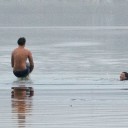
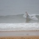
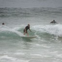
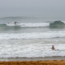
Was up early for a report on 702 ABC this morning. The fog was so thick that I ended up having to drive down to the beach to see what metre of 8sec SE windswell looked like. Visibility at Northy was maybe 400m and there were around 30 people in the water chasing weak waist high little lumps. For the most part the waves had to be worked to extract much speed and the crowd level to consistency ratio was pretty ordinary. But the water is warm and the fog meant there wasn’t any wind to speak of.
After doing the radio thing, I pointed my sturdy old Soobie southward and made for Longy. There too the fog was thick, and despite the SE direction, the waves were smaller on average than at Northy. Still, they were catchable, particularly if you were using a mal or similar. I’d guess the size range between the two spots I looked at will be a pretty good guide to everywhere else in Sydney.
Hey, at least there’s sort of something!
Outlook for the next couple days is shaping to be similar or a bit smaller. I’m still holding out hope for a little pulse on Sunday. The models have been calling for it to appear for some days now, but as usual, their, shall we say enthusiasm, has been fading. Currently the estimate is for sets in the head high range on a 1.5-2m east swell at 12-13 sec. Fingers crossed…
Have yourself a top Australia Day and go well!
Weather Situation
A stationary high pressure system over the eastern Tasman Sea extends a ridge to the New South Wales north coast. A trough and associated southerly change will move along the southern half of the coast today, weakening over the north during Thursday. A more vigorous cold front is expected to affect the entire coast at the end of the week, assisted by a strengthening high south of the Bight.Forecast for Wednesday until midnight
Winds: Northerly 10 to 20 knots tending north to northeasterly up to 30 knots in the afternoon. A southerly change 15 to 25 knots in the evening. Seas: Up to 1.5 metres increasing to 2 metres around midday then increasing to 3 metres by early evening. Swell: Easterly 1 metre. The chance of thunderstorms in the afternoon.Forecast for Thursday
Winds: Southerly 10 to 20 knots, reaching 25 knots at times, tending south to southeasterly 10 to 20 knots around dawn then tending southerly 10 to 15 knots during the morning. Seas: Up to 2 metres decreasing to below 1 metre during the morning. Swell: Northeasterly 1 metre. Swell: Easterly 1 metre tending southerly 0.5 metres from the morning.Forecast for Friday
Winds: Southerly 15 to 25 knots tending south to southeasterly 15 to 20 knots during the evening. Seas: Up to 1.5 metres increasing to 1.5 to 2 metres during the morning. Swell: Easterly 1 metre.