
Hello Friends,
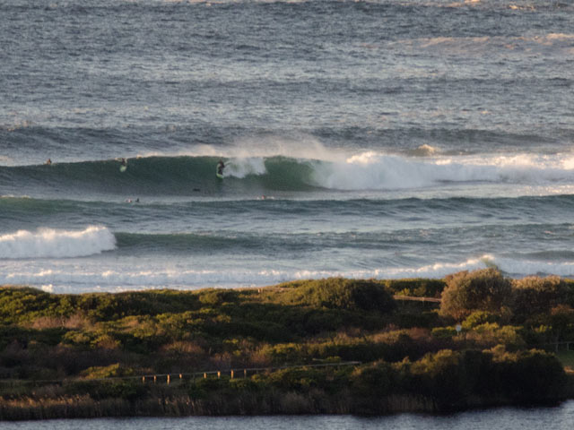
The Huey express pulled into town while we were sleeping and this morning sees offshore wind and around 3.5 metres of 11-12 sec SSE swell. Pumping big time.
Tide was low at 0730 and will hit a highish high at about 1400. Wind will pick up a bit during the day, but stay NW to W through the day.
Outlook is for the pulse to weaken toward midday and be noticeably smaller toward dusk – but that doesn’t mean it’ll be beginner friendly then or anything. We’re talking maybe a metre smaller, so it’ll still be pumping.
The way things are currently shaping up, it’s probably not going to drop below shoulder high at exposed spots for the next week!
Go well and watch before you get in the water, particularly if you’re still getting up to speed with your surfing skills. These long period conditions are serious and you really can get into trouble when it’s like this.
Weather Situation from the BoM
A slow-moving, strong high pressure system southwest of the Bight is extending a ridge to the southern Coaral Sea while cold fronts are moving across the southern Tasman Sea maintaining strong to gale force winds along New South Wales coast.
Forecast for Friday until midnight
Winds
West to northwesterly 10 to 15 knots increasing to 15 to 20 knots during the afternoon then becoming westerly 20 to 25 knots later in the evening.
Seas
Up to 1.5 metres increasing to 1.5 to 2 metres by early evening.
Swell
Southerly 2 to 3 metres.
Saturday 9 July
Winds
Westerly 20 to 25 knots increasing to 20 to 30 knots by early evening.
Seas
Up to 3 metres decreasing to 2 metres around dawn then increasing to 3 metres by early evening.
Swell
Southerly 2 to 3 metres.
Weather
Large swells breaking dangerously close inshore.
Sunday 10 July
Winds
Westerly 20 to 25 knots increasing to 20 to 30 knots during the morning.
Seas
1.5 to 2 metres increasing to 3 metres during the morning then increasing to 4 metres during the evening.
Swell
Southerly 3 metres.
Weather
Large swells breaking dangerously close inshore.
Please be aware
Wind gusts can be 40 percent stronger than the averages given here, and maximum waves may be up to twice the height.
Nearby Coastal WatersThis forecast is also available via scheduled broadcasts on marine radio.
Northern Coastal Waters Forecasts (PDF)
Central Coastal Waters Forecasts (PDF)
Southern Coastal Waters Forecasts (PDF)
The next routine forecast will be issued at 4:05 pm EST Friday.
Product IDN11009


