
Hello Friends,
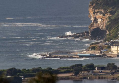
Tide had just passed the 1.4 m high when I grabbed the pictures this morning and as you can see, it looked pretty fat, full …and small. There weren’t any takers that I could see and I’d say it’s around knee to maybe, possibly, waist high up the beach where the metre or so of SSE swell will be a little more focused. Wind should be going north to NE 15-25 kts later, so now is the plan if you can. Tide will be back to the low at 1315, by which time that wind should be well into it.
The models are showing our energy levels hanging around the current subdued levels until Saturday when they continue to show a south pulse in the 2m/10sec range arriving and then fading over the next couple of days.
Have yourself a top old Tuesday everyone!
Weather Situation
A high pressure system over the Tasman Sea is directing northeasterly winds over New South Wales waters. A weak trough is forecast to bring a southerly change to southern parts of the coast on Tuesday and central parts on Wednesday.
Forecast for Tuesday until midnight
Winds
North to northeasterly 15 to 25 knots.
Seas
1.5 to 2 metres.
Swell
Southerly below 1 metre.
Weather
Cloudy. 80% chance of showers.
Wednesday 4 October
Winds
Northerly 15 to 20 knots tending south to southeasterly 10 to 15 knots in the middle of the day then tending northeasterly in the evening.
Seas
1 to 2 metres, decreasing to 1 metre during the morning.
Swell
Northeasterly below 1 metre inshore, increasing to 1 to 1.5 metres offshore during the morning.
Weather
Partly cloudy. 20% chance of a shower.
Thursday 5 October
Winds
South to southwesterly about 10 knots tending northeasterly 10 to 15 knots during the afternoon.
Seas
Below 1 metre.
Swell
Northeasterly around 1 metre.
Weather
Partly cloudy. 50% chance of showers

