Archive for June 2019
Postcards from Cali: tiny Saturday
Posted on June 30th, 2019 in At large.
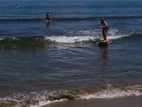
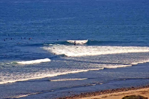
Hello Friends,
Visited Ventura yesterday, so came back along the coast this afternoon and grabbed a few snapshots of the non-action. Lovely day though!

Lots of driftwood from winter on the beach at the cove at Rincon

Up and riding on microbump at Rincon

With the right equipment you can ride anything at Rincon

Learner learning at Hobson’s just south of the La Conchita pier which you can see in the background of Rincon videos.

No waves at The Wall a few kms south of Rincon.
Saturday morning and ya got next to nothin’
Posted on June 29th, 2019 in Surf Reports.Hello Friends,
Just had a look at surf conditions in Sydney a little before 0700 and waves are just about not there. From what I could see, ‘surf’ was in the ankle to knee high range at best. The MHL buoy was seeing a metre at 7 seconds from the SSE and wind was coming lightly from the NNW. Tide was high at 0415 and is dropping to low at 1025. Water temp is around 19C.
The swell models continue to show an influx of easterly swell from tomorrow. It could be into the shoulder high range by dusk on Sunday and then dialling up to head to overhead on Monday at magnets. Throw in a call for W-SW wind, and cool but mostly sunny skies through midweek, and I’d say you’re in for some fun!
Weather Situation
A high pressure system near New Zealand extends a ridge to the north coast, directing easterly winds along the north coast and northerlies along the south coast. A vigorous cold front is also approaching from the west, causing winds to turn northerly throughout and strengthen in the south. Winds then shift west to southwesterly on Sunday as the front sweeps through.
Forecast for Saturday until midnight
Strong Wind Warning for Saturday for Sydney Coast
- Winds
- Northerly 15 to 25 knots, reaching up to 30 knots offshore in the late evening.
- Seas
- 1 to 1.5 metres, increasing to 1.5 to 2.5 metres during the afternoon.
- Swell
- East to northeasterly around 1 metre inshore, increasing to 1 to 1.5 metres offshore during the morning.
- Weather
- Partly cloudy.
Sunday 30 June
- Winds
- Northerly 15 to 20 knots, reaching up to 25 knots offshore early in the morning. Winds shifting southwesterly during the morning and decreasing to 10 to 15 knots in the evening.
- Seas
- 1.5 to 2.5 metres, decreasing to 1 to 1.5 metres during the morning, then decreasing below 1 metre by early evening.
- Swell
- Northeasterly 1 to 2 metres, tending easterly 1.5 to 2.5 metres during the morning.
- Weather
- Mostly sunny.
Monday 1 July
- Winds
- Southwesterly 10 to 15 knots becoming variable about 10 knots during the morning.
- Seas
- Below 1 metre.
- Swell
- Easterly 2 metres.
- Weather
- Mostly sunny.
POSTCARDS FROM CALI

Campus Point too tiny to catch today

Pretty much flat everywhere, but Lowers still has something

Central California’s Steamer Lane, not steaming but if you have a longboard…
Tge Goat’s Surf Forecast
Posted on June 28th, 2019 in Goat's Forecast.Forecast for the rest of Friday
- Summary
- Mostly clear.
- Chance of any rain: 10%
Sydney area
Mostly clear. Light winds.
Sun protection not recommended, UV Index predicted to reach 2 [Low]
Saturday 29 June
- Summary
- Min 10
- Max 21
- Sunny.
- Chance of any rain: 10%
Sydney area
Sunny. Fog in the morning, mainly in the west. Light winds becoming northerly 15 to 25 km/h in the middle of the day.
Sun protection not recommended, UV Index predicted to reach 2 [Low]
7 day Town Forecasts
Precis Icon | Location | Min | Max |
---|---|---|---|
![]() |
Sydney | 10 | 21 |
![]() |
Penrith | 6 | 22 |
![]() |
Liverpool | 6 | 21 |
![]() |
Terrey Hills | 9 | 19 |
![]() |
Richmond | 4 | 21 |
![]() |
Parramatta | 7 | 21 |
![]() |
Campbelltown | 4 | 21 |
![]() |
Bondi | 12 | 20 |
Sunday 30 June
- Summary
- Min 13
- Max 19
- Mostly sunny.
- Chance of any rain: 10%
Sydney area
Sunny. Winds northerly 15 to 25 km/h turning west to southwesterly 20 to 30 km/h in the morning.
Sun protection not recommended, UV Index predicted to reach 2 [Low]
Monday 1 July
- Summary
- Min 7
- Max 17
- Mostly sunny.
- Chance of any rain: 0%
Sydney area
Mostly sunny. Areas of morning frost in the west. Light winds.
Sun protection not recommended, UV Index predicted to reach 2 [Low]
Tuesday 2 July
- Summary
- Min 7
- Max 18
- Mostly sunny.
- Chance of any rain: 5%
Sydney area
Mostly sunny. Light winds.
Wednesday 3 July
- Summary
- Min 8
- Max 19
- Possible shower.
- Possible rainfall: 0 to 2 mm
- Chance of any rain: 40%
Sydney area
Partly cloudy. Medium (40%) chance of showers. Light winds becoming southeasterly 15 to 20 km/h during the day.
Thursday 4 July
- Summary
- Min 12
- Max 18
- Shower or two.
- Possible rainfall: 1 to 5 mm
- Chance of any rain: 60%
Sydney area
Cloudy. Medium (60%) chance of showers. Winds southerly 15 to 20 km/h.
Friday 5 July
- Summary
- Min 12
- Max 18
- Shower or two.
- Possible rainfall: 2 to 5 mm
- Chance of any rain: 60%
Sydney area
Partly cloudy. Medium (60%) chance of showers. Light winds
So very small either side of the pond
Posted on June 28th, 2019 in At large.
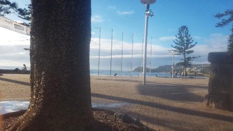
Hello Friends,
My S.O. sent me a phone snap from south Steyne this morning on her way to work. It looks very tiny, but she said there were a few people at the Queensie end. Dee Why was flat and according to the Bus Man, up the peninsula was no better.

microness at South Steyne under clearing skies.
Looking at the MHL data for Sydney as of 0700 there was a metre of 7-sec SE bump wafting into the beaches. Tide was running out to the low at around 1100. Wind was coming faintly from NNW as you head to a high of 20C. Ocean’s on 19C according to the fine folk of Beachwatch.
Outlook isn’t too exciting for tomorrow, but by gee next week sure looks good for Sydney on the models. Sadly we’re in full summer mode here in southern California. Santa Barbara is zippo and even up north at Santa Cruz and down south, the waves are really, really tiny most places. There seems to be some slight hope for late next week though…
Have yourself a great day!

Flat at Leadbetter point in Santa Barbara around lunch time tody
From the bus man on his way to the salt mines
Posted on June 28th, 2019 in Surf Reports.Slothful Friday morning surf.
Somewhere between Mona Vale and Newport …….. limpid.
Seawall building activity at Collaroy. Anyone seen a plan for this?
Looked okay at Bungan early
Posted on June 26th, 2019 in Surf Reports.
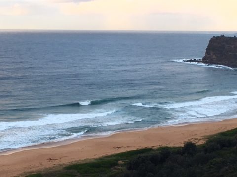
Our loyal busman sent a snap of Bungan this morning, but I was jolting around Santa Cruz island until late this afternoon… so apologies about the tardiness..

Sweet peak from the bus to work this morning…
A few more postcards from Santa Cruz island
Posted on June 26th, 2019 in At large.
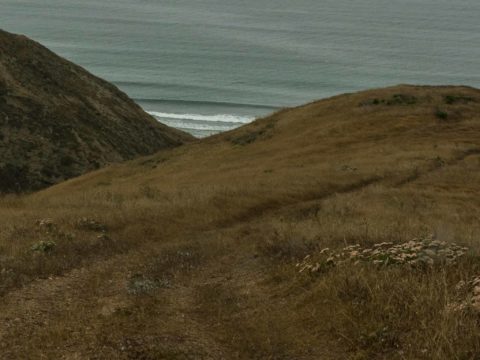
Hello Friends,
Looks like Sydney is really messy and not offering much in the way of quality on the wave front today. 10-15 kts of SSE wind can’t be helping matters…
Meanwhile your correspondent spent another day lurching and crawling along the narrow “4-wheel drive in low only” roads of Santa Cruz island as I helped my brother run a couple more drone survey flights – and took time to grab a few snaps to share. Weather here continues heavily overcast and foggy (not unusual this time of year), but we had enough ceiling for the flights.
Surf here at Christy’s (not Christies as earlier stated) ranch beach remained very small and glassy. Nice long south lines though…

Christy’s west end of Santa Cruz island’s south facing coast

Near the east end of Christy’s

Same ridge as other pic, but looking north west

Up on a ridge looking to the east

North facing slopes get most of the moisture from the prevailing wind and in the steeper canyons can be very thick. This is one of the biggest oaks I’ve seen

Cub 2

Cub 1

Pair of Island fox cubs greeted us at one point.
Post cards from the island
Posted on June 25th, 2019 in At large.Hello Friends,
Looks like Sydney surf conditions are pretty bad today. Southerly wind and showers and junky swell as best I can make out.
So, thought I’d send along a few postcards from Santa Cruz Island off the coast of southern California where I’m currently helping my brother on a research project that involves drone imaging. We’re at the west end of the island, staying in some old ranch buildings from last century. The area we’re in is really only accessible to researchers, so there are no other people around and no signs of human activity beyond the remnants of the old ranch. The landscape looks a lot like it did a couple hundred years ago (but for an abundance of Fennel and other introduced plant species). (I’m using the research facility’s internet link to post this as there’s no phone service out here)
More fieldwork all day again tomorrow, so I may or may not be able to send a few more postcards…
Have a great day and hope you get waves again soon

My brother flying a drone as part of a Santa Cruz island research project

Hey South Australia, there’s another Christies Beach on Santa Cruz island

Santa Cruz Island Kit Fox was almost wiped out, but now the cat size creature is getting re-established after decades of conservation work.

Probably a metre of face on this tiny SW line at the beach near the research station at the old Christie’s ranch on Santa Cruz island.
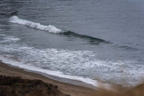
Short period and windy for the early
Posted on June 23rd, 2019 in At large.
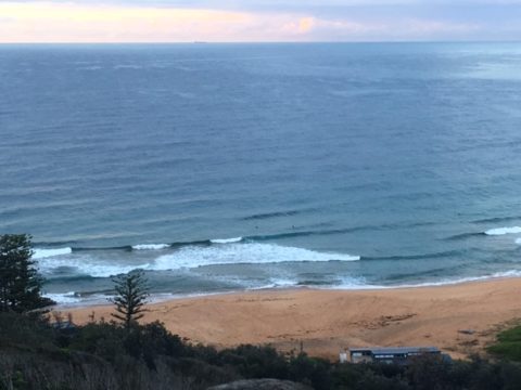
Hello Friends,
Sunday morning saw offshore WSW breezes for the early and a 7 second period 2.7m wind swell from the S-SSE. Inshore you’d be lucky to see much above shoulder high faces on sets, but magnets might have the odd bigger one. Lots of showers out to sea as I write this and the wind should be picking up soon. Rain is a certainty according to the Bureau. Beachwatch says the water has slipped down another degree to 19C. Given the high is going to be 16C, I’m guessing a steamer is the plan.
Tomorrow looks like being problematic windwise, but Tuesday, particularly for the early could potentially be more interesting. Wave energy levels look like being maybe a little less than today’s peak, but right now it appears that there should be surfable stuff around the waist high range give or take for the rest of the week.
Here in California things continue along in usual summer fashion. Santa Barbara is flat, but as you head south toward Mexico, the SW groundswell becomes a factor. Once again we had tiny, barely surfable stuff in Ventura, but very fun looking head to head plus at magnets like Trestles down south of LA. Your correspondent may or may not be able to stay in touch over the next 4 days as he’ll be out on Santa Cruz Island just off the Ventura-Santa Barbara coast. If there’s an internet connection, I’ll try to get a few postcards to you.
Go well with your Sunday!
Weather Situation
A high pressure system lies over southeast Australia for the remainder of the week, before shifting into the southern Tasman Sea on Monday. This will maintain mostly southeast to southwesterly winds over New South Wales waters.
Forecast for Sunday until midnight
Strong Wind Warning for Sunday for Sydney Coast
- Winds
- South to southwesterly 15 to 25 knots, reaching up to 30 knots during the morning. Winds turning southeasterly 10 to 15 knots in the late afternoon.
- Seas
- 1.5 to 2.5 metres.
- Swell
- Southerly 2 to 2.5 metres, tending southeasterly 2 metres later in the evening.
- Weather
- Cloudy. Near 100% chance of showers. The chance of a thunderstorm. Possible waterspouts.
Monday 24 June
- Winds
- Southeasterly 10 to 15 knots, reaching up to 20 knots offshore during the morning and early afternoon.
- Seas
- 1 to 1.5 metres.
- Swell
- Southeasterly 2 to 2.5 metres.
- Weather
- Partly cloudy. 95% chance of showers. The chance of a thunderstorm.
Tuesday 25 June
- Winds
- Southeasterly 10 to 15 knots decreasing to about 10 knots during the morning.
- Seas
- Below 1 metre.
- Swell
- Southeasterly 1.5 to 2.5 metres.
- Weather
- Partly cloudy. 80% chance of showers.
POSTCARDS FROM CALI

Super tiny at California Street

Bit textured but another day of fun size and rippable waves for ontestants at Lower Trestles
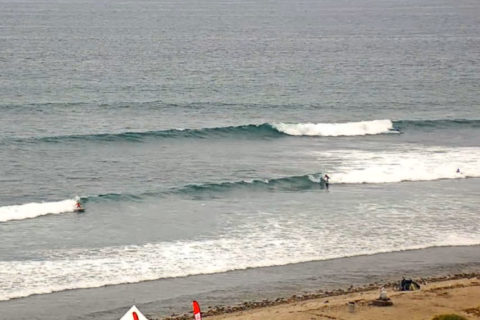
Saturday surf report
Posted on June 22nd, 2019 in At large.Swell is up – about 3-5 metres offshore but as it’s from dead South most of that is going straight by.
Beaches that are open to the South have waves of some sort, say around 2 2+ metreish – while beaches protected from South swell are tiny to small…The swell period is 6.8-9.7 jut under the magic ten required to start getting some refraction around points and into S corners.
But the big factors at the moment is the tide – low was just before 6 so banks are very shallow and dangerous in some places – and the wind chill. While the air temperature is 8, the apparent temp is ZERO to ONE on the coast – it’s blowing right thru you.
There are a few out at some places, but today really it’ll be only the young, the hardy and those with no feelings who’ll be interested. I told a mate who went in the other day when it was really cold, “you have no feelings.” His wife said “I’ve been saying that about him for years!”
Wind is currently from the west but is expected to turn SW. Water temp has dropped to 19.
igh tide will be around 11:50am
Tomorrow the surf should be in the 2-3 metre range at dead South places; some waves should get into protected corners.
For the rest, check in with The Goat.
Rog.