Articles tagged with "E-2m-10s"

Beautiful morning

This entry was posted by: Don on June 24th, 2009

Out the back of the Narrabeen Firey's joint.

Out the back of the Narrabeen Firey's joint.Huey settles down This entry was posted by: Don on May 25th, 2009
Mostly smaller and much weaker than this one at 0715.

Mostly smaller and much weaker than this one at 0715.

Hello Friends,

Much less choppy this morning, but the swell has dropped pretty dramatically as well. It’s still out of the east (so not too great for Dee Why, which is the only place I’ve looked at so far today). Winds were lightly west and are expected to go N-NE but to weaken further as the day goes along. Bureau says it’ll be mostly fine with the possibility of a shower along the coast early.

Couple of bods were out at Dee Why when I took the photo, but they were struggling to get much. Catchable set waves looked to be fairly intermittent. Size on the sets seemed to be in the shoulder to head high range, so it ain’t flat. But the more average waves were half that whilst I was watching.

Outlook is for the energy levels to decline through the day, but with luck it’s not going to drop into the flat range. The models are currently suggesting that Wednesday will be about the best combo for us this week; shoulder high from the ESE and offshore is the estimate. Thereafter the wind goes more southerly and periods drop back, even as the average size gets back into the 2+ metre range. So windswelly, the odd shower, generally southerly and not too spectacular is the call for late in the week.

Go well with your endeavours and have yourself a top old day!

Next tide is a high at 0843, the low is at 1415.

Sydney Coastal Waters, Broken Bay to Port Hacking and 60nm seawards:
Monday until midnight: Wind: N/NE 10/15 knots, easing to 5/10 knots.Sea: about 1 metre.Swell: E/SE about 2 metres, decreasing.
Tuesday: Wind: W/NW 5/10 knots, turning NE during the afternoon.Sea: less than 1 metre.Swell: E/SE 1 to 1.5 metres.
Wednesday: Wind: Early SW change 10/20 knots, SE later.

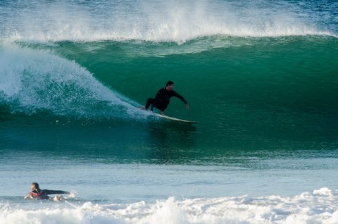
Good size at Dee Why

This entry was posted by: Don on April 16th, 2009

The first snap of the day… more to come in the next hour or two…

If you’re interested, here’s a link to yesterday evening’s wrap up post with a heap of pics…

0630: looks at least as big as yesterday morning...

0630: looks at least as big as yesterday morning...

Sunday evening

This entry was posted by: Don on April 5th, 2009

Wrapping up the weekend and what do we have? Well, today the swell started out at 2 metres from the SSE at 9sec, but by lunch time it was back around to the east at 10 seconds and still around the two metre mark. It was offshore and relatively clean at most places to begin with, but in keeping with the forecast, the wind came around to the NE and is currently NNE at 15-20 kts or so.

Outlook for tomorrow morning isn’t too crash hot. The Bureau says we’ll have a 20-30 kt south change before dawn and although it’ll ease off to 15-20 kts later, the direction will be S-SE. Swell should still be rolling along. Bureau reckons it’ll be 1.5-2 m from the east, swinging around to the S and building a touch to 2-3 metres. High tide’ll be at 0427 dropping to a lowish low at 1115.

Here’s a snap I took just on dusk.

That's Sunday done. Wind around to NE, but swell not gone.

That's Sunday done. Wind around to NE, but swell not gone.

Out and about midday Sunday

This entry was posted by: Don on April 5th, 2009

Sorry about the daily pic gallery showing yesterday… a new bug to chase down, oh joy. Anyway, lotsa average quality waves around for the Sunday crowds. No such thing as a decent uncrowded wave from Northy to Fairy Bower. In fact, I’d guess the same applies up to Palm Beach and I’m pretty sure the eastern suburbs and the Shire will be much the same. Lot of water time getting racked up today – hope you got some!

Here are a few snaps taken at Manly and Curly around lunchtime…

Bigger one looking empty at Winki.

Bigger one looking empty at Winki.

The north end was well populated this afternoon at North Curly.

The north end was well populated this afternoon at North Curly.

Mild, some swell and Sunday adds up to very crowded.

Mild, some swell and Sunday adds up to very crowded.

Somewhat junky but okay size at Queenscliff.

Somewhat junky but okay size at Queenscliff.

A few pics from south Narra this am

This entry was posted by: Don on March 29th, 2009

Tide was not far off high and the swell was focusing on the Collaroy Narrabeen stretch, particularly the mid section near Gardens. I got a few pictures for ya (see below). Over 90 percent of set waves were shutting down, but there were some folks prepared to take off anyway…

29mar09snb_2117

29mar09snb_2124

29mar09snb_2129

29mar09snb_2135

29mar09snb_2143

29mar09snb_2148

29mar09snb_2162

29mar09snb_2166

29mar09snb_2171

29mar09snb_2183

29mar09snb_2187

29mar09snb_2194

29mar09snb_2197

29mar09snb_2221

29mar09snb_2233

29mar09snb_2234

29mar09snb_2242

29mar09snb_2254

29mar09snb_2240

Gardens this am

Gardens this am

Gardens this am

Gardens this am

Virtually all the big ones were shutting down.

Virtually all the big ones were shutting down.

Some were just a bit too steep to make the drop.

Some were just a bit too steep to make the drop.

Gardens this am

Gardens this am

Plenty of juice on tap this morning.

Plenty of juice on tap this morning.

Gardens session this morning on high tide.

Gardens session this morning on high tide.

Moment of fun near Gardens.

Moment of fun near Gardens.

Looking mighty fine

This entry was posted by: Don on March 29th, 2009

Hello Friends,
Time to go surfing. I’m calling it 6-8/10 at spots that are liking the 2 metres of 10 sec east swell. Glassy and breaking hard from south of Mactier St to Northy. Nice from Dee Why Centre to No Man’s and beyond. I’m going for a closer look asap

the bureau sez

Sunday until midnight: Wind: NW/NE 8/13 knots, becoming E/NE 10/15 knots in the afternoon. Sea: about 1 metre. Swell: E/SE 1 to 1.5 metres.

Just part of the crowd at Northy this morning.

Just part of the crowd at Northy this morning.

More madness along the Collaroy-Narrabeen stretch.

More madness along the Collaroy-Narrabeen stretch.

One of many crunching peaks to be found along the Coll-Narra stretch.

One of many crunching peaks to be found along the Coll-Narra stretch.

Another one winds down the line at Dee Why beach.

Another one winds down the line at Dee Why beach.

Monday and waves

This entry was posted by: Don on September 8th, 2008
0650: we still have a fair amount of swell on tap this morning.

0650: we still have a fair amount of swell on tap this morning.

Hello Friends,

Looks as though we still have plenty of wave energy around this morning. For instance, it seems that the sets are just a bit too big to allow many folks to get out to the peaks breaking off Dee Why beach. The point was occupied from first light of course, but given the size, it wasn’t that crowded. And the wind is lightly offshore under sunny skies. Nice looking combo.

The swell does look fairly lumpy still, so you couldn’t call the conditions all time (well, not at Dee Why anyway). The MHL Sydney buoy is showing that it’s two metres at 10 seconds from the E. There is some 12 sec component in there as well, so I’d be expecting a few bomb sets in the mix this morning.

Our wind call from the Bureau today is for W-SW 10-15 kts early, swinging S-SW and getting up to 20-25 kts by lunchtime.

The low responsible for our swell has headed off into the Tasman in the usual way, but instead of dissipating as often happens, the Bureau says it’s intensifying and that should mean that the surf won’t go away for a few days yet. In fact, I’d expect it to stick around at about the current size, but to be coming from the southern quarter through to the middle of the week.

I’ll try to get a few more piccies from around the place today, but in case you missed it, here are a few links to some I shot yesterday. This batch includes Brownwater and Manly, this group is from south Narra and this one is from the Bower and Winki.

Enjoy and go well with your day!