Smallish but sets

Hello Friends, The 0500 MHL directional spectra chart for Sydney was showing 1.9 metres of 9-second E-ENE energy. Two hours later when your servant climbed aloft for a squizz at Dee Why it was, as the pictures show, around the chest mark on sets. Wind was very light so the surface was smooth, if lumpy. […]
South wind, but some bumps for the keen
Hello Friends, Mix of east and south swell this morning under gloomy skies. The surface is a bit chopped up but since it’s coming from the SSW at 15-20 kts, the bump wasn’t that bad at Dee Why this morning. The wind will probably go more around to the south as we head […]
Waves!
Hello Friends, Fun looking, if not super clean, 9 second period east swell of a couple metres lighting up the joint. Set waves are in the head high plus range at Dee Why point and it seemed to be pretty consistent too. Tide is low at about 0815 and winds were light for the early. […]
Waves about this morning
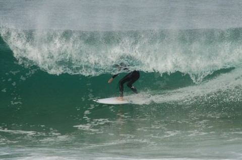
Hello Friends, Still a couple metres of more easterly swell around this morning. Sets at exposed spots are shoulder high plus. At Dee Why that meant bigger and more consistent in the beachy than at the point. Around at Collaroy-Narra stretch, the southern extent had its share of picturesque looking shutdowns […]
PICS: Friday late morning, North Narrabeen
Friday the 29th of June saw a couple metres of 9-10 sec period east swell rolling into Sydney’s beaches. I took an hour out to shoot the action at North Narrabeen from about 1110 to 1210. At that stage there were a few tasty rights coming in at Carparks as well as the standard high […]
Saturday funday
Hello Friends, Yep, waves again this morning everybody. Get thee to an east swell spot and prepare to enjoy the occasional head high set for your efforts. There were 50 plus in the water at Dee Why from the No Man’s to Kiddies. The real energy was more to the north […]
Up a bit this morning
Hello Friends, Light offshores and a scrappy but bigger than yesterday east wind swell at about 9 seconds apart and nearly two metres at sea. There was even a bit of watery sunshine about at 0700 when I first looked at it. But the skies have clouded over again as I write this. Looks like […]
Cool, breezy, cloudy and small at Dee Why
Hello Friends, Once again you’d have to say of Dee Why that it would better to look elsewhere. It can be okay, even good, with the right east swell, but not always, or even often. The MHL buoy off Sydney is showing a couple metres of 9 second near east swell, but Dee Why is […]
Tidier and some chest high sets too
Hello Friends, Ocean looks much better this morning. Swell is around to the east now. It was close to two metres out at the MHL buoy and the average period is about 9 seconds. We’re heading into a sunny Wednesday with light offshores for the early which are expected to wander around to SE later, […]
Hazy skies early, fluffy looking waves as the wind fades
Hello Friends, Just a quick note, will follow up later. This morning sees light onshores and a couple metres of east windswell are combining to deliver so-so but surfable conditions at Dee Why. Average wave height looks to be around the waist to chest high mark. Weather Situation A strong slow-moving high pressure system over […]