Hello Friends,
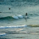
Beating the NE’r this morning is the plan for Saturday. Either that, or just taking it head on and waiting until the wind is really blasting (around lunchtime). Exposed stretches such as the north end of Collaroy-Narrabeen stretch are showing waist high sets with the odd chest high bomb. Less optimally aligned stretches such as Dee Why are knee high with bombs making it to waist high.
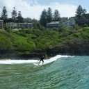
If you’re willing to brave onshore conditions, you might want to leave it until this afternoon when the wind is supposed to be up to 30 knots, so that should mean the odd head high plus face in exposed locations. And remember, although the ocean will be pretty torn up, the faces are actually relatively clean so if you pick your section, it can be kinda fun.
Tide is high at around midday.
When it comes to the outlook, I’m with the Goat. If you had to pick a day this weekend for maximum size potential, I’d say it’d be today. Tomorrow is setting up to be more northerly and that means that there probably won’t be quite as much energy in the system as compared to later today. That said, it doesn’t look like being flat either.
On current reckoning Monday could offer similar size to later today with a more easterly swell direction lighting up a wider variety of spots. So, all and all, a marginal, but not woeful outlook.
Have yourself a great day!
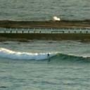
Postcard from lovely Bilgola at about 1045 this morning…

Weather Situation
A semi-stationary high pressure system near New Zealand extends a ridge to to New South Wales far north coast. A cold front front is expected to move across the southwestern Tasman Sea during Sunday bringing brief southerly change to the south coast.
Forecast for Saturday until midnight
Winds: North to northeasterly 15 to 25 knots becoming northeasterly up to 30 knots around midday. Seas: 1.5 to 2 metres increasing to 3 metres around midday. Swell: Northeasterly 1 metre.
Forecast for Sunday
Winds: Northerly 20 to 30 knots. Seas: Up to 3 metres decreasing to 2 metres during the morning. Swell: Northeasterly about 1.5 metres. Isolated thunderstorms in the afternoon and evening.
Forecast for Monday
Winds: Northwesterly 10 to 20 knots. Seas: Up to 1.5 metres increasing up to 2 metres during the morning. Swell: Easterly 1 metre.