Hello Friends,
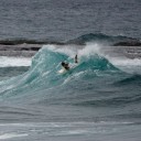
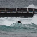
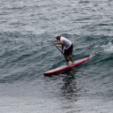
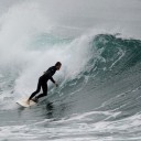
Swell is dead south after yesterday’s change, and as the day got started it was coming down from hitting a peak of 4 metres at 10 sec during the dark hours. At 0700 it was still chuffing along at 3 metres and close to 10 sec. That’s more vigorous than the models had originally projected but the reality is nothing like you’d expect from the numbers. Although it was lightly offshore this morning, there weren’t too many people in the water at Dee Why. The problem was that the swell wasn’t really working and even the biggest sets were struggling to deliver head high wave faces. And mostly it was much smaller than that. Every now and then a catchable one hit the point, but you needed a SUP or a mal to have much of a shot.
Went up to North Narrabeen to get another fix on the swell and discovered three or four extra keen types (in wetties because of the cool air temps) trying to extract something from what was really a chaotic situation. Like Dee Why it wasn’t all that big in the corner (it was a bit more solid at carparks, but unsurfable), and worse, waves would pop up and then double or cancel out as earlier waves bounced back into the oncoming swell.
A bit of a disappointment one would have to say.
Outlook is for the downward trend to continue through the day as the swell fizzles out to near flatness for tomorrow morning. However, according to the models, this should just be a brief lull as a new long period south pulse fills in. The pulse looks like peaking during the night hours but it should still be around on Wednesday morning.
Here’s hoping…
Go well with your day!
TIDES: H @1130 L @1750
Weather Situation
A strong high pressure system is moving towards Tasmania extending a ridge to New South Wales north coast. The high will move over the southern Tasman Sea by Wednesday and then it will move slowly towards New Zealand during Thursday and Friday maintaining the ridge to the north coast.Forecast for Monday until midnight
Winds: Southerly 15 to 25 knots tending south to southeasterly 10 to 15 knots around midday. Seas: Up to 2 metres decreasing to below 1 metre by early evening. Swell: Southerly about 2 metres.Forecast for Tuesday
Winds: South to southeasterly 5 to 10 knots becoming southerly 10 to 15 knots around midday then increasing to 15 to 20 knots by early evening. Seas: Below 1 metre increasing to 1.5 metres later in the evening. Swell: Southeasterly 0.5 to 1.5 metres.Forecast for Wednesday
Winds: South to southeasterly 15 to 20 knots tending east to southeasterly 10 to 15 knots during the afternoon. Seas: 1 to 1.5 metres decreasing to below 1 metre during the evening. Swell: Southerly 0.5 to 2 metres.