
Hello Friends,
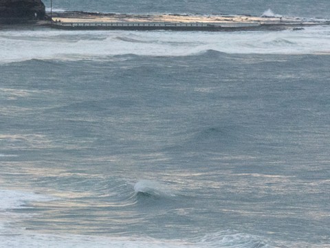
Yesterday at 2pm beachwatch was warning that every beach in Sydney – bar Avalon – was either likely to have pollution or that it was possible. So the water’s going to be pretty ordinary. The wind call is for 15-25 kts of southerly, but as the day got started, the morning offshore effect was at work. Swell at 0500 was 2.5 metres from the S to SE at a touch under 10 seconds apart.
Tide was low at 0500 and will peak at 1100 before dropping back to low at 1635.
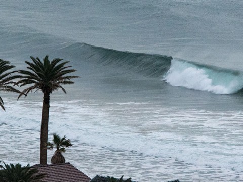
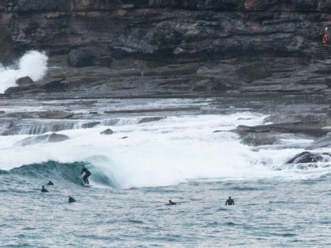
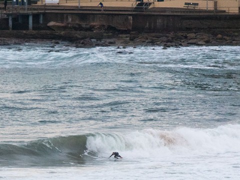
Surface conditions this morning for the early were comparatively smooth and as long as you didn’t care about the swill factor, there were some waves at Dee Why point and just up the beach. Around at Narrabeen there was energy as well, but no one in the water from Northy to south of Mactier Street. Around at Dee Why the beachy was challenging looking with set wave faces into the head high range but the makeable ones very few and far between. The point was entertaining a small (for Saturday) crew with chest to shoulder plus on the sets.
Outlook is for the swell to fade gradually across the day. But, since the southerly will be kicking in, it doesn’t matter much. Tomorrow looks likely to be southerly all day, but come Monday the wind should not be a major factor and the models are currently showing 12-14 sec period 1.5 metre south swell… wonder how the water’ll be…
Have a great day and a big thanks to everybody who came along to the International Surfing Day bash last night at the Diggers. Surfrider raised some dough for the cause and Celibate Rifles raised the roof for everybody. A brilliant night!
.
.
.
.
Weather Situation
A weak low near Lord Howe Island will move further away to the east today. A strong high pressure system currently south of the Bight will move slowly east to lie over Victoria later Saturday and over southeast NSW by Sunday night before moving over the Tasman Sea during Monday. Strong winds over most coastal waters today will gradually ease over the weekend.
Forecast for Saturday until midnight
Strong Wind Warning for Saturday for Sydney Coast
Winds
Southerly 15 to 25 knots, reaching up to 30 knots in the morning.
Seas
2 to 3 metres, decreasing to 1 to 2 metres during the morning.
Swell
Southerly 1.5 to 2.5 metres, decreasing to 1.5 metres during the afternoon.
Weather
Cloudy. 80% chance of showers. The chance of a thunderstorm during the morning and afternoon.
Sunday 21 June
Winds
Southeast to southwesterly 10 to 15 knots becoming variable about 10 knots in the early afternoon.
Seas
Around 1 metre, decreasing below 1 metre during the morning.
Swell
Southerly 1.5 metres, tending southeasterly 1 to 1.5 metres during the afternoon, then tending southerly 1.5 metres by early evening.
Weather
Cloudy. 50% chance of showers.
Monday 22 June
Winds
Variable about 10 knots becoming northerly 10 to 15 knots during the day.
Seas
Below 1 metre.
Swell
Southerly 1.5 to 2 metres, decreasing to 1 to 1.5 metres during the afternoon or evening.
Weather
Partly cloudy. 20% chance of a shower.


