
Hello Friends,
Still some wave energy around as the sun sinks in the west. The surface conditions were pretty ordinary though. A light east breeze has been messing it up since late morning and from the look of the latest forecast, it’ll be up to it’s naughty tricks again tomorrow.
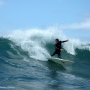
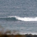
Swell’s out of the south at a couple metres right now, but it’s getting a little push thanks to the 10-12 second average period. I got in the water at the point for a bit and managed to jag a few fun ones. Sets were coming along in the chest to head high range at reasonably regular intervals and the aforementioned push was welcome. (My camera was playing up, so although I shot a fair amount, the results aren’t all that interesting sadly.)
I reckon it could drop overnight because the average periods have started going down since about midnight at Eden. They’ve dropped into the 8 second range there, so if that flows through to us (as seems pretty likely), tomorrow could be smaller and weaker than today. However, if the models have it right, there should still be surfable options at south swell spots (that onshore will be an issue of course)
High tide tomorrow will be around 0800 and low will be about 1400.
Weather Situation from the BoM
A series of lows are passing through the southern Tasman Sea, with associated cold fronts extending northwards towards the NSW coast. One of these will pass along the southern NSW coast later today, and is expected to reach the Sydney coast overnight. A persistent ridge of high pressure over NSW is gradually extending further eastwards and will bring easing winds and afternoon coastal sea breezes.
Forecast for Wednesday until midnightWinds: East to northeasterly 5 to 15 knots. Seas: Below 1 metre. Swell: Southerly 2 metres.
Forecast for ThursdayWinds: East to southeasterly 5 to 10 knots tending northeasterly later in the evening. Seas: Below 1 metre. Swell: Southerly about 2 metres.
Forecast for FridayWinds: North to northwesterly 5 to 10 knots tending north to northeasterly 10 to 15 knots around midday then tending north to northwesterly 10 to 20 knots later in the evening. Seas: Below 1 metre increasing up to 1.5 metres later in the evening. Swell: Southerly 1.5 metres.
Forecast for SaturdayWinds: West to northwesterly 10 to 15 knots tending southeast to southwesterly up to 10 knots during the afternoon then tending northeast to southeasterly during the evening. Seas: Below 1 metre. Swell: Southerly 1.5 metres.


