
Hello Friends,
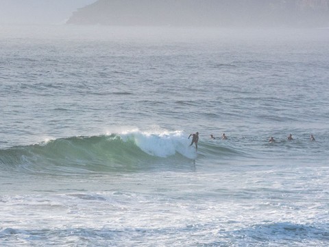
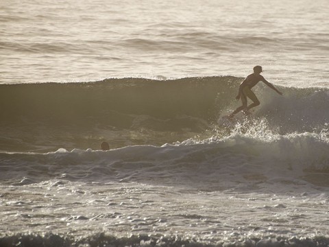
Drove by Curly, Dee Why and south Narra for a look this morning. Tide was making it kind of fat and conditions were relatively glassy, but lumpy and closing out wherever there were waves. Curly had the odd shoulder high wave face on take-off, but you’d be doing well to squeak in a couple of quick turns before it shut down. At Dee Why the energy levels were a touch lower, maybe chest-ish on set wave faces. It was less consistent and again, if there was any size, it pretty much always ended quickly in a close out. It was bigger at south Narrabeen, but essentially unmakeable because the close-out count was so high. There were only three or four in the water near Marquesas, which tells you a great deal when set wave faces are approaching head high on the bigger ones.
So, we’ve got another morning of short period NE windswell which the Bureau predicts will drop as the day goes along. Tide hits high at 1025 so it’ll be getting fatter and the wind will be into it by the time the tide starts to get low again.
Be interesting to see what the Goat thinks about our prospects. From the shape of this morning’s forecasts, there could be an uptick tomorrow morning and the next week looks like at least offering a steady supply of scrappy but rideable if you’re keen wind swell.
Have great Thursday!
Weather Situation
A high pressure system near New Zealand will move slowly east over the next few days maintaining a ridge to the northwest while a low pressure system over the Coral Sea moves south and weakens. This pattern will direct generally east to northeasterly winds along New South Wales coast except for a brief southerly change on the south coast later on Friday. The next, stronger southerly change is expected to develop along the southern half of the coast on Sunday.
Forecast for Thursday until midnight
- Winds
- Northeasterly 15 to 20 knots.
- Seas
- Around 1 metre, increasing to 1 to 1.5 metres offshore.
- Swell
- Easterly 1.5 to 2 metres, decreasing to 1 to 1.5 metres during the morning.
- Weather
- Partly cloudy. 70% chance of showers. The chance of a thunderstorm during the morning and afternoon.
Friday 23 January
- Winds
- Northeasterly 15 to 20 knots.
- Seas
- 1 to 1.5 metres, increasing to 1.5 to 2 metres around midday.
- Swell
- Easterly 1.5 to 2.5 metres.
- Weather
- Partly cloudy. 40% chance of showers in the morning and afternoon. The chance of a thunderstorm offshore in the afternoon.
Saturday 24 January
- Winds
- Northeasterly 15 to 20 knots.
- Seas
- 1.5 to 2 metres, decreasing to 1 to 1.5 metres during the morning.
- Swell
- Easterly 1 to 2 metres, decreasing to 1.5 metres during the afternoon or evening.
- Weather
- Partly cloudy. 20% chance of a shower. The chance of a thunderstorm in the morning and afternoon.

