Hello Friends,
Up before daybreak for an airport run, so just a quick round up of the conditions. I plan to post pictures and so on this afternoon, so check back later to see what I’ve found…
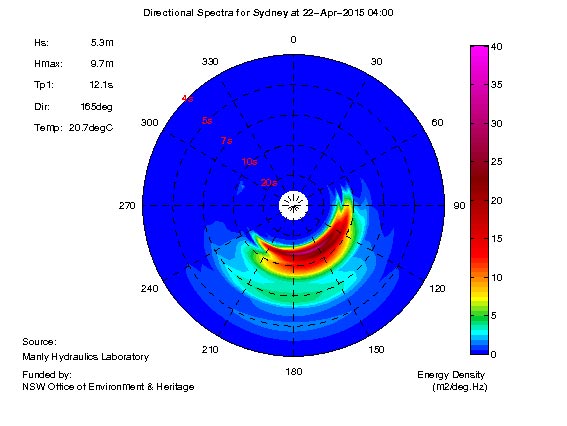
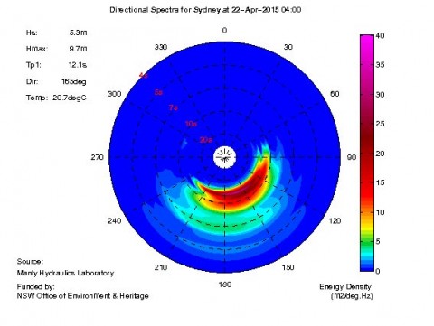
At 0400 the MHL Sydney buoy was showing 5.3 metres of 12-sec SSE swell. Peak heights (swell + seas) was a whopping 9.7 metres. Winds have moderated in line with expectation, but it was still in the 25-30 kt range from the south as of 0530.
Outlook is for swell to start dropping back as the day goes along and by evening, the Bureau predicts average swell in the 2-3 metre range and on Thursday to be a mix of east and south swells dropping into the metre plus range by dark. Thursday winds look to be SW. Friday it’s back to a metre or so again, but with light winds and mostly sunny conditions.
And then there’s this:
“Surfrider Foundation has notified us that the severe weather conditions have caused a power failure at North Head Wastewater Treatment Plan resulting in about 40 million litres of heavily diluted, partially treated wastewater entered the ocean off the cliff face at North Head. Take caution if you are planning a surf at Manly in the next day or so.”
Due to wet weather, Sydney Water advises of an on-going partial bypass of secondary biological and tertiary filtration treatment at the Cronulla WWTP and Warriewood WWTP commencing on the 20th April 2015. Please contact Sydney Water for further details.
Pollution was shown as likely at all beaches yesterday and I doubt the rain overnight will have improved things.
Not that it matters, but tide’s low at 0500 and high again at 1105
Weather Situation
A slow-moving low pressure system off the Hunter coast will gradually lose intensity today, and by Thursday is expected to have decayed into a broad trough over the Tasman Sea. This weakening trend will lead to improved conditions over New South Wales coastal waters. A weak ridge will extend across from the west as the low loses influence, and should linger until the weekend when the next frontal system brings the next surge of southerly winds to the New South Wales coast.
Forecast for Wednesday until midnight
Gale Warning for Wednesday for Sydney Coast
Winds
Southwest to southeasterly 20 to 30 knots, reaching 35 knots inshore during the day.
Seas
2 to 3 metres.
1st Swell
Southerly 3 to 5 metres, tending southeasterly 2 to 3 metres in the evening.
2nd Swell
Easterly 1 to 1.5 metres.
Weather
Cloudy. 90% chance of rain, possibly heavy at times. The chance of a thunderstorm.
Caution
Large and powerful surf conditions are expected to be hazardous for coastal activities such as crossing bars by boat and rock fishing.
Thursday 23 April
Winds
South to southwesterly 15 to 20 knots decreasing to 10 to 15 knots in the afternoon.
Seas
1 to 2 metres.
1st Swell
Southeasterly 1.5 to 2 metres, decreasing to around 1 metre by evening.
2nd Swell
Easterly around 1 metre.
Weather
Partly cloudy. 50% chance of showers.
Friday 24 April
Winds
Variable about 10 knots becoming northwesterly 15 to 20 knots during the morning then tending westerly during the evening.
Seas
1 to 1.5 metres.
Swell
Easterly 1 to 1.5 metres.
Weather
Partly cloudy. 20% chance of a shower. The chance of a thunderstorm in the evening.
Please be aware
Wind gusts can be 40 percent stronger than the averages given here, and maximum waves may be up to twice the height.
Nearby Coastal Waters


