
Hello Friends,
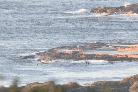
Tide’s coming of an 0500 high as it drops to low at 1110. As of 0600 the main swell energy was still out of the SSE. It was about 1.3 metres and the average period was a healthy 14 seconds. That longish period is likely to mean a setty experience at the magnet spots. The point looked to be around knee with the odd waist and the beach about the same, maybe a touch bigger. But, that said, the only people I could see in the water were at the point so your mileage may vary.
Surface conditions were nice and smooth under clear skies. Wind was lightly from the NW and the Bureau tells us to expect it to say that way. Interestingly they also say the swell should be mainly NE and around a metre but the MHL data shows the NE component to be almost purely in the 12 second range, while the SSE component contains everything from 7 to 15 second energy. So, we can probably expect the odd long, lined up sets from the NE every now and again, but most of the activity will be out of the south.
It’ll be interesting to see what the Goat’s take is, but from my reading of the models, it seems we’re likely to stumble along at about the current swell intensity until early next week when we might get a little uptick from the south. The wind should be offshore and likely pretty strongly so.
Have yourself a great Thursday one and all and go well with your plans!
Weather Situation
A strong high pressure system over the western Tasman Sea extends a ridge across New South Wales waters. The high will slowly drift east over the next day or so. The next cold front is expected to move across southern waters late Friday and central parts of the coast during Saturday. Winds should then shift east to northeasterly and strengthen during Sunday as a low pressure system develops over the northern inland of New South Wales and tracks southeast, with the low possibly moving over southern waters on Monday.
Forecast for Thursday until midnight
Winds
Northwesterly 10 to 15 knots, tending north to northwesterly 15 to 20 knots offshore.
Seas
Around 1 metre, increasing to 1 to 1.5 metres offshore during the morning.
Swell
Northeasterly around 1 metre, increasing to 1 to 1.5 metres offshore.
Weather
Mostly sunny.
Friday 17 June
Winds
North to northwesterly 15 to 20 knots, reaching up to 25 knots offshore in the late morning and afternoon.
Seas
1 to 1.5 metres, increasing to 1.5 to 2 metres offshore during the morning.
1st Swell
Easy to northeasterly 1 to 1.5 metres.
2nd Swell
South to southeasterly around 1 metre.
Weather
Partly cloudy. 40% chance of rain. The chance of a thunderstorm offshore in the afternoon and evening.
Saturday 18 June
Winds
West to northwesterly 15 to 20 knots becoming west to southwesterly about 10 knots during the morning then becoming southerly during the evening.
Seas
1 to 1.5 metres.
Swell
South to southeasterly below 1 metre.
Weather
Cloudy. 80% chance of rain.


