Archive for April 2019
Postcards: Crescent morning
Posted on April 30th, 2019 in At large.
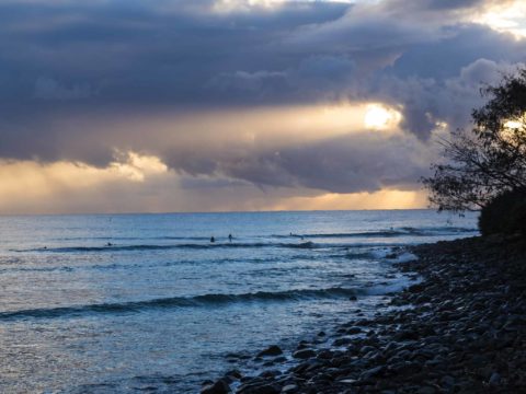
Hello Friends,
After an overnight rain shower or three, woke up this morning to find glassy conditions and only a dozen in at the point. It was knee to waist with the odd chest high set wave, so the choice was easy – grab the mal and get out there. Water was warm and waves were getting smaller and steadily less consistent, but we jagged a few tasty little runners. lotta fish action too, and at one point my board was a FAD for a tiny bait ball of 1 cm long fry. Poor little critters were getting hammered by the 10 cm bigger ones. But those guys were getting chased by 30 cm tailor along with the odd passing Tern. Life and death struggles going on all around.
Had planned to make for the far north coast today, but a close examination of the forecasts makes me think we’d be making an effort for onshore and very tiny and weak waves. So, will try again next week…
In the meantime, some pictures from this morning…

Slow roller 0645

Typical set

Spectacular sky effects

Do-able looking little line at Crescent Head this morning
Postcards from Saltwater and Crescent
Posted on April 29th, 2019 in Surf Reports.
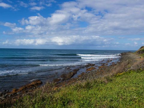
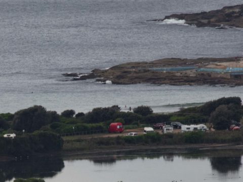
Hello Friends,
Got in the water around midday at Saltwater. Set faces were in the chest to shoulder plus range, wind was light, water was warm and it wasn’t particularly crowded. Swell was rather weak and slow, which made me glad that I’d opted for my mal…

Set wave up the point at Saltwater

Cruising one at Saltwater

Picturesque little waves at Saltwater, early afternoon
We got into Crescent around 1545 and discovered that getting in at Saltwater earlier had been the right move. Swell was getting around the top of the point and there were a few keen types getting amongst it, but the waves were knee to waist high and quite inconsistent. Also, as at Saltwater, they were very slow too. Not overly hopeful about tomorrow morning’s prospects…
Smoke pollution to start the day
Posted on April 29th, 2019 in Dee Why.Hello Friends,
Taking off on surfari today, but hoped to have a pic to share of conditions posted before I took off. Unfortunately while the skies along the beaches were clear higher up, a strong inversion layer was trapping so much smoke pollution in the first 200 m or so that I couldn’t see the beach from RealSurf HQ. Can’t imagine how these conditions are for people with respiratory problems.
So, I’ll have to make do with the data points for now and hope that I’ll be able to sling a pic up from my travels later.
Wind was light westerly as of 0740 and out at the MHL buoy off Sydney, there was 1.5 metres of 10 second SSE swell. That’s up just a touch over yesterday at this time when south magnets were getting the odd waist high set. Tide was low at 0400 and will be back to a 1.3 m high at 1050.
Weather Situation
A high pressure system over southeastern Australia will mainly bring light winds to the Waters today. This high will drift east over the Tasman Sea by this evening, where it will remain slow moving for most of the week, directing north to northeasterly winds over the Waters from Tuesday onwards.
Forecast for Monday until midnight
- Winds
- South to southwesterly about 10 knots becoming southeasterly in the early afternoon then becoming east to northeasterly in the late evening.
- Seas
- Below 1 metre.
- Swell
- Southerly 2 to 3 metres.
- Weather
- Partly cloudy.
Tuesday 30 April
Strong Wind Warning for Tuesday for Sydney Coast
- Winds
- East to northeasterly below 10 knots tending north to northeasterly 10 to 15 knots before dawn then becoming northerly 15 to 25 knots in the middle of the day. Winds reaching up to 30 knots in the evening.
- Seas
- Below 1 metre, increasing to 1 to 1.5 metres around midday, then increasing to 2 to 2.5 metres by early evening.
- Swell
- Southerly 1.5 to 2 metres, decreasing to 1 to 1.5 metres during the morning.
- Weather
- Mostly sunny.
Wednesday 1 May
- Winds
- Northerly 20 to 30 knots decreasing to 15 to 20 knots during the morning.
- Seas
- 1.5 to 2.5 metres.
- 1st Swell
- Southerly around 1 metre.
- 2nd Swell
- Northeasterly around 1 metre.
- Weather
- Partly cloudy.
Curses, hoped for waves this morning
Posted on April 28th, 2019 in Dee Why.
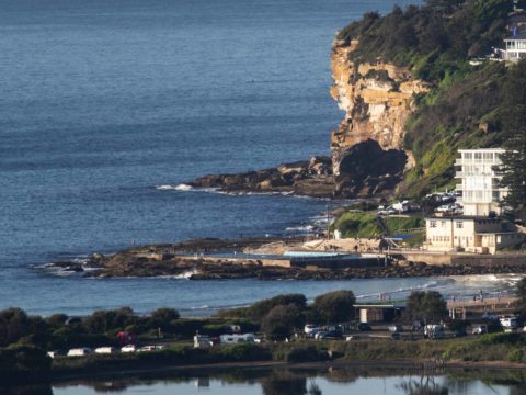
Hello Friends,
From nearly 3 metres yesterday morning to 1.3 metres for Sunday’s early session saw wave faces back in the knee to maybe waist high range at Dee Why. Swell was close to 11 seconds apart, but dead south and not very consistent. A couple of bods in the water at the point when I checked for the first time around 0800, but they didn’t catch anything and along the beach it didn’t look much more promising. Wind was 8-10 kts from the west. Tide is currently heading toward the low at 1000. It’ll be back to a 1.28 high at 1630. Beachwatch says water quality’s good and temp is sitting on 22C.
Outlook is for it to stay really small today, but it might bump up a little tomorrow – when your correspondent will be on surfari and heading up the coast. Expect more postcards!

Back to tiny at the point

Knee high at Kiddies – on sets

Up the beach it’s good for paddling
Weather Situation
A high pressure system near Adelaide is extending a ridge into the state from the west. This high will drift across southeast Australia today before reaching the Tasman Sea on Monday, where it will remain slow moving for most of the week, directing north to northeasterly winds over the Waters from Tuesday onwards.
Forecast for Sunday until midnight
- Winds
- Northwest to southwesterly 10 to 15 knots tending south to southwesterly in the middle of the day then tending south to southeasterly in the late afternoon.
- Seas
- Around 1 metre.
- Swell
- Southerly 1.5 to 2 metres.
- Weather
- Sunny.
Monday 29 April
- Winds
- Southerly 10 to 15 knots turning east to southeasterly below 10 knots in the late afternoon.
- Seas
- Around 1 metre.
- Swell
- Southerly 2 to 3 metres.
- Weather
- Partly cloudy.
Tuesday 30 April
- Winds
- North to northeasterly 15 to 20 knots increasing to 20 to 25 knots during the evening.
- Seas
- Around 1 metre, increasing to 1.5 to 2 metres during the afternoon or evening.
- Swell
- Southerly 1.5 to 2 metres, decreasing to 1 to 1.5 metres during the morning.
- Weather
- Mostly sunny.
Swell at last
Posted on April 27th, 2019 in At large.
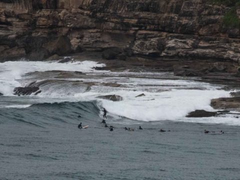
Hello Friends,
Swell looks to be peaking for the early. Set wave faces are into the shoulder to head high range. At 0500 the Sydney buoy was seeing 2.6 metres of 10 second dead south swell. Judging by the reports south of us, the current peak size will only last a few hours before dropping back to around 2 metres. Longish waits are the order of the day and the best spots are well populated. Swell is hitting south spots but not doing much elsewhere. Wind was light SW before 0700 and with luck won’t go too hard later. Water’s about 22C.
Should get sunny later too.
Although the swell is set to fade back into the waist high range tomorrow, wind is set to be offshore, so it could be a fun one in a low-key sort of a way. And, with luck, the small-but-surfable conditions should hold into Mon-Tue. And, depending on the model you look at, there seems to be some hope of little waves for the rest of the week.
No Mans 0645

Busy at the point

Not super consistent but fun size on the bombs

Well attended at the point 0645

Outside Kiddies

Smaller ones in the mix

Near the Pole at 0640

Long Reef

Maybes at Northy
Weather Situation
A strong cold front brought a vigorous south to southwesterly change to southern and central waters yesterday, extending to the Queensland border this morning. Winds should gradually ease during today and Sunday as a high pressure system slowly drifts across from the west, reaching the Tasman Sea early in the new week. This high is expected to remain the dominant feature in the region for a number of days.
Forecast for Saturday until midnight
- Winds
- Southerly 15 to 25 knots becoming variable about 10 knots in the late afternoon.
- Seas
- 1.5 to 2.5 metres, decreasing below 1 metre during the afternoon.
- Swell
- Southerly 2 to 3 metres.
- Weather
- Partly cloudy.
- Caution
- Large and powerful surf conditions are expected to be hazardous for coastal activities such as crossing bars by boat and rock fishing.
Sunday 28 April
- Winds
- West to northwesterly 10 to 15 knots turning southwesterly in the middle of the day then becoming variable about 10 knots in the late afternoon.
- Seas
- Around 1 metre.
- Swell
- Southerly 1.5 to 2.5 metres.
- Weather
- Sunny.
Monday 29 April
- Winds
- Southerly 10 to 15 knots becoming variable about 10 knots during the morning.
- Seas
- Below 1 metre.
- Swell
- Southerly 1.5 to 2.5 metres.
- Weather
- Partly cloudy.
Zippo on the surf front this morning
Posted on April 26th, 2019 in Dee Why.Hello Friends,
We’re still in a holding pattern. There’s a strong wind warning for later in the day, but it’s not going to improve the surf situation. Out at sea the bump is under a metre and coming from the SSE at 10 seconds. But inshore, as the pictures show, it’s in the ankle to shin high range. Tide was low at 0800 and will be back to a 1.2 metre high at 1400. We’re due to reach a 28C high today which isn’t record breaking but is around 10C above historical averages.
If you’re wondering about the week ahead, may I defer to the deep wisdom of the Goat
Have a great Friday everyone!

Another microscopic morning at Dee Why

Out for a paddle up the beach
Weather Situation
A weakening high pressure system over the Tasman Sea extends a ridge to the northern New South Wales coast, while a strong cold front approaches from the southwest. This front will bring a vigorous south to southwesterly change to southern and central waters today, extending to the Queensland border early Saturday. Winds should gradually ease later Saturday and Sunday as a ridge of high pressure drifts across from the west. This high is expected to remain the dominant feature in the region for a number of days.
Forecast for Friday until midnight
Strong Wind Warning for Friday for Sydney Coast
- Winds
- Northwesterly 10 to 15 knots turning west to southwesterly 15 to 25 knots in the middle of the day, then south to southwesterly 20 to 30 knots in the evening.
- Seas
- 1 to 1.5 metres, increasing to 2 to 3 metres by evening.
- Swell
- Northeasterly around 1 metre.
- Weather
- Sunny.
Saturday 27 April
- Winds
- Southerly 15 to 20 knots, reaching 25 knots offshore in the morning.
- Seas
- 1.5 to 2.5 metres, decreasing below 1 metre during the afternoon.
- Swell
- Southerly 1.5 to 2 metres, increasing to 2 to 3 metres during the morning.
- Weather
- Partly cloudy.
- Caution
- Large and powerful surf conditions are expected to be hazardous for coastal activities such as crossing bars by boat and rock fishing.
Sunday 28 April
- Winds
- Northwesterly 15 to 20 knots becoming variable about 10 knots during the day then becoming south to southeasterly 10 to 15 knots during the afternoon.
- Seas
- 1 to 1.5 metres, decreasing to 1 metre during the morning.
- Swell
- Southerly 1 to 1.5 metres inshore, increasing to 1.5 to 2 metres offshore.
- Weather
- Sunny
The Goat’s Surf Forecast
Posted on April 25th, 2019 in Goat's Forecast.The Goat’s Surf Forecast
Surf forecast issued Thursday 25 April 2019: Seven day outlook for Sydney:
Fabulous weather for ANZAC Day and great to see ever increasing numbers taking a little time out of such a beaut day to pay their respects for those who’ve served their country at Dawn Services and later Commemorations…
Water temp is a very pleasant 23 ish – great for a swim before or after, but not so great fro a surf with very small to nothing conditions.
Tomorrow morning expect something similar first off, then not a lot resulting from a SW change. Coming up a little through the week – not a lot – at places that are open to dead South, but quality may not be all that great.
Friday: similar to Thursday at first then even more ordinary
Saturday: coming up into the 1-2 metre range at dead South places only
Sunday: a lot of due South in it so could be going straight past.. 1-2 metres
Monday: 1-2 metre range dead South, with some sets
Tuesday: 1-2 metre range South East with more getting in
Wednesday: going down to around 1 metre or so East
Thursday: down more 1 metre or less East.
There you go.
TG
Up in the Sky
Winds
https://www.windy.com/-33.855/151.216?-34.373,151.216,8,i:pressure,m:cIJaknc
Down in the Sea
Water temp is around 23ish ..very pleasant
Tides
Weather from the BoM
Forecast for the rest of Thursday
- Summary
- Clear.
- Chance of any rain: 10%
Sydney area
Mostly clear. Light winds.
Sun protection recommended from 9:30 am to 2:10 pm, UV Index predicted to reach 5 [Moderate]
Friday 26 April
- Summary
- Min 17
- Max 27
- Sunny.
- Chance of any rain: 10%
Sydney area
Sunny. The chance of morning fog, mostly in the west. Light winds becoming west to northwesterly 15 to 25 km/h in the morning then tending west to southwesterly 25 to 35 km/h in the middle of the day.
Fire Danger – High
Sun protection recommended from 9:40 am to 2:10 pm, UV Index predicted to reach 5 [Moderate]
7 day Town Forecasts
Precis Icon | Location | Min | Max |
---|---|---|---|
![]() |
Sydney | 17 | 27 |
![]() |
Penrith | 15 | 28 |
![]() |
Liverpool | 14 | 27 |
![]() |
Terrey Hills | 15 | 26 |
![]() |
Richmond | 14 | 28 |
![]() |
Parramatta | 14 | 27 |
![]() |
Campbelltown | 13 | 26 |
![]() |
Bondi | 18 | 26 |
Saturday 27 April
- Summary
- Min 13
- Max 19
- Partly cloudy.
- Chance of any rain: 20%
Sydney area
Partly cloudy. Slight (20%) chance of a shower along the coastal fringe in the early morning. Winds southwesterly 15 to 20 km/h.
Sun protection recommended from 9:50 am to 1:50 pm, UV Index predicted to reach 4 [Moderate]
Sunday 28 April
- Summary
- Min 10
- Max 23
- Sunny.
- Chance of any rain: 0%
Sydney area
Sunny. Winds west to northwesterly 15 to 20 km/h becoming light during the morning.
Sun protection recommended from 9:40 am to 2:00 pm, UV Index predicted to reach 4 [Moderate]
Monday 29 April
- Summary
- Min 11
- Max 23
- Mostly sunny.
- Chance of any rain: 5%
Sydney area
Mostly sunny. Light winds.
Tuesday 30 April
- Summary
- Min 12
- Max 25
- Mostly sunny.
- Chance of any rain: 0%
Sydney area
Mostly sunny. Light winds.
Wednesday 1 May
- Summary
- Min 15
- Max 27
- Partly cloudy.
- Chance of any rain: 5%
Sydney area
Partly cloudy. Light winds.
Thursday 2 May
- Summary
- Min 17
- Max 23
- Possible shower.
- Possible rainfall: 0 to 4 mm
- Chance of any rain: 40%
Sydney area
Partly cloudy. Slight (30%) chance of a shower. The chance of a thunderstorm later in the day. Light winds becoming southeasterly 15 to 20 km/h during the morning
Fine and waveless for Anzac Day
Posted on April 25th, 2019 in Dee Why.
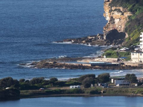
Hello Friends,
A perfect morning for the Anzac ceremonies in Sydney. Wind was coming faintly from the west before 0800. The MHL buoy was seeing 0.8 of a metre from the east at 9 seconds apart. As the pictures show, the consequence at Dee Why was smooth but flat conditions.
The forecast says we can expect sunny conditions all day as we go to a high of 25. The ocean is 21C according to Beacthwatch and all beaches are suitable for swimming. Tide was low at 0705 and will hit a moderate 1.24 m high at 1300.
The Goat should be along later with an outlook for the week ahead. I hope he sees something encouraging because it’s been a dire start to autumn after an equally dire summer. We’re all getting lots of practice on tiny waves and it’d be nice to have something more challenging…
Go well with your Thursday!

Micro at Dee Why

Smooth sea 0730
Weather Situation
A high pressure system over the Tasman Sea extends a ridge to the northern New South Wales coast, while a trough is bringing a southerly change to southern waters today. This trough will weaken overnight, although a strong cold front is forecast to bring a vigorous south to southwesterly change to southern and central waters on Friday, extending to the Queensland border early Saturday. Winds should gradually ease later Saturday and Sunday as a ridge of high pressure from the west becomes the dominant feature over New South Wales.
Forecast for Thursday until midnight
- Winds
- Variable about 10 knots becoming northerly 10 to 15 knots in the evening.
- Seas
- Below 1 metre.
- Swell
- Northeasterly around 1 metre.
- Weather
- Sunny.
Friday 26 April
Strong Wind Warning for Friday for Sydney Coast
- Winds
- North to northwesterly 10 to 15 knots shifting west to southwesterly 15 to 25 knots in the middle of the day, reaching 30 knots offshore in the evening.
- Seas
- Around 1 metre, increasing to 2 to 2.5 metres by evening.
- 1st Swell
- Southerly below 1 metre inshore, increasing to 1 to 1.5 metres offshore in the evening.
- 2nd Swell
- Northeasterly around 1 metre.
- Weather
- Sunny.
Saturday 27 April
- Winds
- Southwesterly 15 to 20 knots tending southerly 15 to 25 knots during the morning then becoming variable about 10 knots during the afternoon.
- Seas
- 1.5 to 2.5 metres, decreasing below 1 metre during the afternoon or evening.
- 1st Swell
- Southerly 1.5 to 2 metres, increasing to 2 to 3 metres during the morning.
- 2nd Swell
- Easterly around 1 metre.
- Weather
- Partly cloudy
Beautiful morning but not if you want a wave
Posted on April 24th, 2019 in Dee Why.Hello Friends,
Home again for a few days, and hoping for a wave like everyone else, but it looks like we’re outta luck. Ocean at Dee Why looks to be ankle to knee high – on the bigger ones. Swell is about a metre from the east at 8-9 seconds. Wind’s out of the WNW as of 0830, but it should go around to the NE soon.
Be interestng to see what the Goat says about our prospects for the coming week. His words of wisdom should be up by this evening.
Have a top old day, and if you go looking for surf, may you find more than I’m seeing right now!

Tiny wavelet peels into the beach at 0800

Dee Why basking waveless in the sun
Weather Situation
A high pressure system over the Tasman Sea is directing east to northeasterly winds over much of the coast while a southerly change is forecast to cross the southern half of the coast later Wednesday and during Thursday in association with a front slipping to the south. Then a more significant front is forecast to cross the state on Friday, bringing a fresh to strong south to southwesterly change in its wake. Winds should gradually ease from Saturday as a ridge of high pressure from the west becomes the dominant feature over New South Wales.
Forecast for Wednesday until midnight
- Winds
- North to northeasterly about 10 knots.
- Seas
- Below 1 metre.
- Swell
- Northeasterly around 1 metre.
- Weather
- Partly cloudy.
Thursday 25 April
- Winds
- North to northwest about 10 knots turning southerly 10 to 15 knots from the late morning or early afternoon, becoming east to northeasterly 10 to 15 knots during the evening.
- Seas
- Below 1 metre.
- Swell
- Northeasterly around 1 metre.
- Weather
- Sunny.
Friday 26 April
- Winds
- North to northwesterly 10 to 15 knots turning west to southwesterly 20 to 30 knots during the day.
- Seas
- Around 1 metre, increasing to 1.5 to 2 metres during the evening.
- 1st Swell
- Southerly below 1 metre inshore, increasing to 1 to 1.5 metres offshore during the evening.
- 2nd Swell
- Northeasterly around 1 metre.
- Weather
- Sunny.
On the way home
Posted on April 23rd, 2019 in Surf Reports.Hello Friends,
Stopped in Batemans Bay and got up to find the weather clearing but no sign of any surf prospects. Headed north and checked Golf Course/Mollymook (see below), then Bendalong. No waves at the former, and small but starting to blow out at the latter. Given wind and swell combo decided to check in at Shallows. Haven’t been there this century, so it’s changed a fair amount around there since. Like the farm, it’s getting carpeted with development. But the break’s the same and it woulda been good if we had even 50cm more swell. But we didn’t. So off home again…
Shallows

Shallows: soft sets every 10 mins or so

Bendalong getting chewed by the wind

Path

Golf Course Reef too tiny to surf