Pretty pictures from this morning at Crescent Head
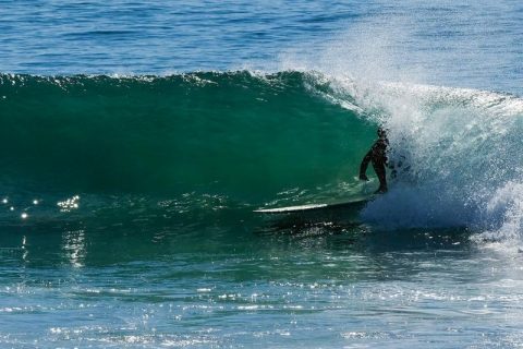
Dropping tide, healthy crowd (40+, lotsa boomers), sunny skies, light offshores and mostly knee to waist but with just enough chest to shoulder sets to keep it fun and interesting. After getting out, I grabbed the Fujifilm X-Pro2 and the 100-400mm lens I have for testing and sat at the top of the point, where […]
Corker but waveless at Dee Why

Hello Friends, Hmmm. Interesting. Another beautiful autumn morning with light offshores but only the tiniest line showing. There were a couple of bods hanging around at the point, but nothing remotely surfable appeared while I watched, and the beach appeared to be unoccupied to at least as far north as No Man’s. Tide was still […]
Tiny waves for the last day of crowdfunding
Hello Friends, Well, our two month campaign is into its final hours. It finishes at 0100 tomorrow morning, so if you’ve been sitting on the sidelines, the time has come to join the more than 200 Friends of RealSurf who’ve already made their pledges. It’d be great to finish up what has been a very […]
Small Sunday
Hello Friends, The MHL buoy is registering about a metre and a bit of east wind swell. Average period is an okay 9 seconds or so and the wind was light and out of the NW before 0900. Tide was incoming to a high at a touch after noon today. A few bods in the […]
A sesh to be had early
Hello Friends, Grey skies start the day, but so do the waves. Not big or anything, but since the energy is mainly from the east at about 9 seconds apart, there should be waist to chest high sets – with the odd plus – this morning. Tide is high at a touch before 1300 and […]
Do something else
Hello Friends, A good Monday to get caught up after a few days of surf – and before the next pulse arrives late tomorrow. Dee Why was very small at 0830 when I grabbed the snap. In fact, I could only see a single surfer bobbing hopefully around amongst those productive banks up the beach […]
A touch smaller again, but still little waves to be found
Hello Friends, Swell is gradually fading away, but for the early risers, there were a few small waves to be had at spots with a liking for east swell. The Bureau says the morning offshore will be pushed away by a south change of 10-20 kts. As you can see from the picture above, set […]
Waves around this morning and that’s a good thing
Hello Friends, High tide at about 0900 and swell is out of the east at about a metre. Period’s close to 9 seconds, so there are chest high sets showing in the beachbreak of Dee Why. There should be a fair number of places lighting up with this particular combo. Wind is light for the […]
As you were
Hello Friends, Not much going on at Dee Why this morning. You want more exposure to the east for the little swell that’s out at sea to have any prospect of a wave. The trendlines are not good for today, but the models show a small perk for tomorrow morning and I’m really liking the […]
PICS: Small but perfectly formed Nth Narrabeen at dusk
A tiny but very clean little east swell combined with a low tide, offshore winds, and nice late afternoon light to create a good picture-taking opportunity. Lotta bods in the water, but there were some surprisingly good looking waves. As usual, if you see yourself in one of these high res shots and want […]