
Hello Friends,
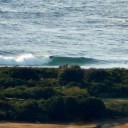
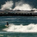
Coming back from my half-yearly appointment with the liquid nitrogen gun I checked the situation from Curly to North Narrabeen. There are some mostly waist high and weak little things getting in for the relatively small number of takers at the latter two spots. The wind’s into it pretty strongly as expected, so you wouldn’t rate the overall quality too highly. But hey, at least you can sorta catch the odd one.
The coming week looks like being mostly about windy afternoon chop chasing at NE spots with relatively smooth but small conditions for the early risers. Today appears to be a reasonable template for right through to Saturday. The long range models aren’t showing anything too exciting at this stage. There don’t seem to be any significant systems coming into either our S-SE or E-NE swell windows, so my best guess is that the next ten days will be dominated by short period wind swell in the knee to waist high range (with the odd bigger one in the afternoons).
Here are a couple snaps from Northy at midday
earlier today I wrote:
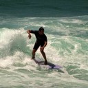
Smooth and small, but not so small tha people at Dee Why this morning couldn’t pick up something. Mostly in the waist high range, but I managed to get a snap of one that was chest high plus. So they are out there if you’re in the spot. The MHL buoy is showing a metre of NE wind swell at about 7 seconds apart. High tide is at around 0920 in Sydney and the low will arrive at 1600. Wind is set to be n-ne 15-25kts later. Might even be a few thunderstorms about.
Will try to get in an update for this afternoon… in the meantime, go well!
Weather Situation from the Bureau for Sydney
A high pressure system over the southern Tasman Sea is slowly moving east. On Monday, the high will become semi-stationary near New Zealand extending a ridge to New South Wales north coast and a cold front will move along the south coast later, before weakening.
Forecast for Monday until midnightWinds: North to northeasterly 15 to 25 knots. Seas: 1 to 2 metres. Swell: Easterly about 1.5 metres. Isolated thunderstorms from midday, contracting offshore late this evening.
Forecast for TuesdayWinds: Northerly 10 to 20 knots. Seas: Up to 2 metres. Swell: Easterly about 1.5 metres. Isolated thunderstorms from the late morning until evening.
Forecast for WednesdayWinds: Northerly 10 to 20 knots. Seas: Up to 2 metres. Swell: Easterly about 1.5 metres. Isolated thunderstorms inshore, extending throughout from the morning.


