Hello Friends,
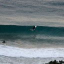
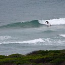
I was pleasantly surprised to discover that the Bureau’s overnight call for early morning southerlies wasn’t quite right. Early risers were treated to glassy, waist high sets at spots that like a bit of east. There’s nothing remarkable about the numbers (the MHL buoy is showing around a metre of 7 second east windswell), but there were definitely little waves to be had.
However, at 0730 when I was writing this, weather stations in the Illawarra were reporting 15-20 kts of south wind. So it’s coming.
TIDES: L @1010 H @1545
Weather Situation
A high pressure system near New Zealand extends a ridge to the New South Wales north coast. A cold front is bringing a southerly change to the southern and central coasts today, but is expected to weaken over the north tonight. Another high pressure system will develop south of the Bight during the weekend, extending a ridge along the New South Wales coast behind the front.Forecast for Saturday until midnight
Winds: An early morning southerly change 15 to 25 knots, reaching 30 knots at times, decreasing to 10 to 20 knots around midday. Winds easing further to around 10 knots in the evening. Seas: 1.5 to 2 metres decreasing to below 1 metre by evening. Swell: Easterly 1 metre. Isolated thunderstorms.Forecast for Sunday
Winds: Southeast to southwesterly 5 to 10 knots tending east to southeasterly 15 to 25 knots around dawn. Seas: Below 1 metre increasing to 1 to 1.5 metres during the morning then increasing to 1.5 to 2 metres during the afternoon. Swell: Southeasterly 1.5 metres.Forecast for Monday
Winds: East to southeasterly 15 to 20 knots. Seas: 1 to 1.5 metres increasing to 2 metres during the morning. Swell: Southeasterly about 1.5 metres.