
Hello Friends,
Overcast with the odd spot of drizzle as Saturday got started. Yesterday’s swell has decreased but as of 0500 it was still showing 3.5 metres of 11-sec energy at the Sydney MHL buoy. Wind when I checked around 0700.
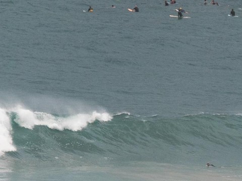
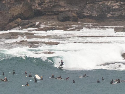
There were tiny waves burbling into Collaroy, while set wave faces were still overhead along Dee Why beach – but kinda lined up and shutting down as we headed toward the high tide at around 1010.
The point was extremely well attended but while I watched it really wasn’t doing much more than offering the occasional shoulder high set to the ravenous crowd. (I went shooting at the point yesterday around midday, so there’ll be a few snaps up later.) I’m sure there’ll still be a few bombs in the mix this morning, but the Bureau says we can expect the swell to gradually run out of puff over the next 24 hours – and for the wind to be onshore by mid morning, first from the SE then later the NE. That said, there should be solid waves at south magnets today and maybe a few fun size bumps tomorrow morning and with luck the wind’ll be okay for the early.
Next week looks marginal to unsurfable but there is some prospect of another pulse – this time more out of the east and potentially with a long period – for next weekend. We’ll keep an eye on it of course.
Have yourself a great Saturday and remember, stay happy!
Weather Situation
A high pressure ridge extends across northern and western New South Wales, while a cold front clips the southeast corner. A weak trough is forecast to linger in the south on Saturday, with remaining areas experiencing a shift to northeasterly winds as a high becomes established over the Tasman Sea. A fairly weak pressure pattern is then expected to remain through much of the coming week.
Forecast for Saturday until midnight
Winds
South to southeasterly 10 to 15 knots becoming northeasterly 15 to 20 knots in the late afternoon.
Seas
Below 1 metre, decreasing below 0.5 metres during the morning, then increasing to around 1 metre around midday.
Swell
Southerly 2 to 3 metres, decreasing to 1.5 to 2 metres by early evening.
Weather
Partly cloudy. 20% chance of a shower later tonight.
Caution
Large and powerful surf conditions are expected to be hazardous for coastal activities such as crossing bars by boat and rock fishing.
Sunday 8 March
Winds
North to northeasterly 10 to 15 knots, reaching up to 20 knots offshore early in the morning. Wind shifting south to southeasterly in the early afternoon.
Seas
1 to 1.5 metres, decreasing to 1 metre during the morning.
Swell
Southerly 1.5 to 2 metres, decreasing to 1 to 1.5 metres during the morning.
Weather
Partly cloudy. 50% chance of showers offshore, 30% chance elsewhere. The chance of a thunderstorm offshore.
Monday 9 March
Winds
North to northwesterly 10 to 15 knots becoming east to northeasterly 10 to 15 knots during the afternoon.
Seas
Below 1 metre.
Swell
Southerly around 1 metre.
Weather
Partly cloudy. 30% chance of a shower.

