
Hello Friends,
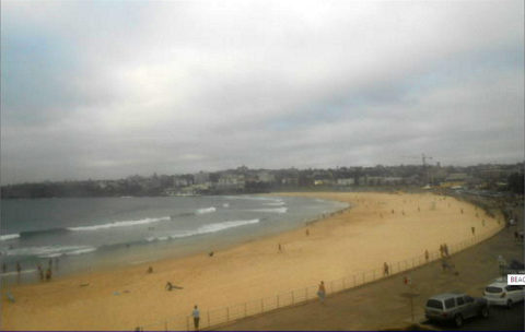
An over the horizon summary for ya. As of 0630 wind was NNE 10-15kts at North Head and skies were grey (there’s a 90% chance of rain today in Sydney). The MHL buoy was picking up 1.6 metres of 6 sec SE bump. There was some 11 sec component in the mix, but looking at the cams there wasn’t really any sign of juice. Most places with SE exposure were knee to occasionally waist and quite soft looking. Tide’s low at 0915.
The Bureau’s posted a strong wind warning (see below) for NE going NW and then southerly. At the same time they’re saying the swell energy will decrease. Tomorrow looks pretty unappetizing with the call being for roaring southerlies and a ramping south swell. Said swell isn’t going to last long, so from here it would seem Sunday early might be the most optimal combo of wind and waves for the weekend.
Looking ahead, well, we have the Goat’s latest as of last night, so I’ll leave today’s Sydney prognosticating in his capable hooves.
It rained in Santa Barbara last night and after mostly clear skies this morning, it looks like storm number 2 is on its way. Surf was confused and marginal, so yours truly is holding off on the 13-14 C water experience a bit longer. I’m not sure I’ve seen as dramatic a swell forecast as we have for this coming weekend here. If the models have it right up north of here on the central California coast there could be 20-30 ft waves at exposed locations. It won’t get as big down here, but I am wondering if this might rival the locally famous monster swell of ’69 (the year I started surfing!)… could be some interesting postcards for you late in the weekend…
Here’s how Sandspit looked on the surfline cam this morning:
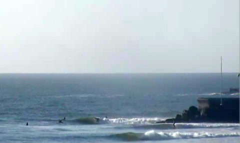
Sandspit, Santa Barbara early this morning
Have a great day everyone!
Weather Situation
A high pressure system over the southern Tasman Sea is directing north to northeasterly winds along the New South Wales coast. A low pressure trough is expected to deepen across New South Wales today and move northeast, with an associated low pressure centre to the south moving over the southern Tasman Sea. This will bring a southerly change along the south coast this afternoon, extending to Sydney Waters overnight and to the far north coast Saturday morning. Winds are expected to turn back to north northeasterly during Sunday as a high pressure system moves east of Tasmania extending a ridge along the coast.
Forecast for Friday until midnight
Strong Wind Warning for Friday for Sydney Coast
Winds
North to northeasterly 20 to 30 knots becoming north to northwesterly 15 to 25 knots in the afternoon then shifting southerly 25 to 30 knots in the late evening.
Seas
2 to 3 metres, decreasing to 1 to 2 metres during the afternoon.
Swell
Southerly 1.5 metres, decreasing to 1 to 1.5 metres during the morning.
Weather
Cloudy. 95% chance of showers. The chance of a gusty thunderstorm during this afternoon and evening.
Saturday 21 January
Gale Warning for Saturday for Sydney Coast
Winds
Southerly 25 to 30 knots, reaching up to 35 knots early in the morning. Winds decreasing to 15 to 25 knots in the afternoon then tending southeasterly in the late evening.
Seas
1 to 2 metres, increasing to 2 to 3 metres during the morning, then decreasing to 1.5 to 2 metres during the afternoon.
Swell
Southerly around 1 metre, increasing to 2 to 4 metres during the morning, then decreasing to 3 metres around midday.
Weather
Partly cloudy.
Sunday 22 January
Winds
South to southeasterly about 10 knots becoming easterly during the morning then tending northeasterly 10 to 15 knots during the afternoon.
Seas
Below 1 metre.
Swell
Southerly 2 to 3 metres, decreasing to 1.5 to 2 metres during the morning.
Weather
Partly cloudy.


