
Hello Friends,
You wouldn’t have wanted to be out at sea in the predawn hours. According to the MHL buoy data the 4.3 m south swell and seas were hitting peaks of 8.4 metres at 0500. Wind along the shore was out of the SW at around 20-30 kts, but Wattamolla was showing 40-50 kts from the south at 0630.
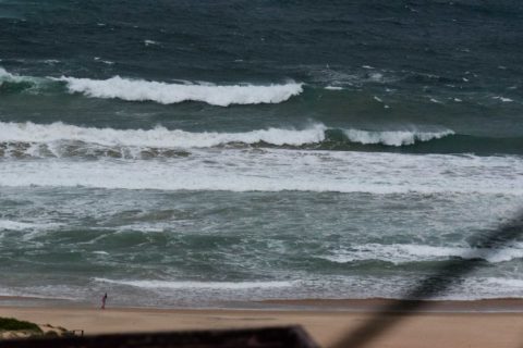
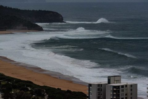
It wasn’t giant along the Collaroy-Narrabeen and Longy-Dee Why stretches when I checked around 0700 this morning ahead of the 702 ABC surf report. But it wasn’t small either. At the most exposed spots, the sets were delivering 2x overhead faces, maybe bigger. The only place I saw anyone in the water was at the point and it looked kinda messy and chaotic despite the wind protection.
Not a great day for a surf in my opinion, and right now tomorrow’s not really looking any better. In fact the week ahead looks ok on the wave supply front, but not good where the wind’s concerned. It’s looking like roaring southerlies until midweek and then steady east through about Thursday at least. Blergh.
Go for a beach walk and pick up a few bits of plastic or other human produced junk you happen to see. You’ll leave the beach a little better than you found it and that’s always a good thing.
Have a great Saturday!


Weather Situation
A complex low pressure system in the Tasman Sea is slowly moving east, while a high pressure centre near Tasmania extends a ridge over western New South Wales. These two systems are combining to generate vigorous southerly winds and large waves. Conditions are expected to ease over the weekend as the low moves further east and a high pressure ridge strengthens in the western Tasman Sea.
Forecast for Saturday until midnight
Gale Warning for Saturday for Sydney Coast
- Winds
- South to southwesterly 30 to 40 knots shifting south to southeasterly 20 to 30 knots in the afternoon.
- Seas
- 3 to 5 metres.
- Swell
- Southerly 4 to 5 metres, tending southeasterly 4 metres later in the evening.
- Weather
- Cloudy. Near 100% chance of gusty showers. The chance of a thunderstorm from late this morning.
- Caution
- Large and powerful surf conditions are expected to be hazardous for coastal activities such as crossing bars by boat and rock fishing.
Sunday 3 June
- Winds
- Southerly 15 to 25 knots.
- Seas
- 1.5 to 2.5 metres.
- 1st Swell
- Southeasterly about 4 metres, tending east to southeasterly about 3 metres in the afternoon.
- 2nd Swell
- Southerly about 1 metre.
- Weather
- Partly cloudy. 90% chance of showers.
- Caution
- Large and powerful surf conditions are expected to be hazardous for coastal activities such as crossing bars by boat and rock fishing.
Monday 4 June
- Winds
- Southerly 15 to 20 knots.
- Seas
- 1 to 1.5 metres.
- Swell
- Southeasterly 2 to 2.5 metres.
- Weather
- Partly cloudy. 95% chance of showers.


