
Hello Friends,
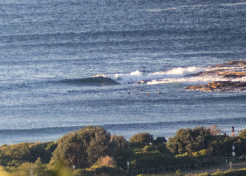
After coming up into the head plus range late yesterday afternoon, the swell energy levels have dropped back into the waist high range at Dee Why as Wednesday got started. Out at sea it was 1.7 metres at 8 seconds from the SSE and wind was 10-15 kts from the west with an air temp on 14 C as of 0730.
The models have been calling this lull for a few days now and the Bureau’s forecast reflects their prediction for an increase in energy as the day goes along. If it all goes according to expectations, it should be solid this afternoon and through tomorrow into Friday.
Tide was high 0545 and will bottom out again at 1145. So, that means this afternoon’s surge will have the extra push of an incoming tide. Unfortunately as the swell pulses up, the wind is set to go around to the south and stay that way through to tomorrow afternoon.
I’ll be keeping an eye on proceedings, so check in later for a few pics (I hope!)

Weather Situation
A high pressure system is currently centred over the Bight, with a low over the central Tasman Sea. Between these systems, a vigorous south to southwesterly airstream is affecting New South Wales waters, particularly southern and central parts. During the next day or two the high will shift east, and is forecast to be over southeast Australia by late Thursday. This is expected to bring an easing of winds during the latter part of the week, although hazardous surf conditions are likely to linger.
Forecast for Wednesday until midnight
Gale Warning for Wednesday for Sydney Coast
Winds
Southwesterly 20 to 30 knots, turning southerly in the afternoon and reaching 35 knots offshore.
Seas
2.5 to 3 metres, increasing to 3 to 4 metres around midday.
Swell
Southerly 1 to 2 metres, increasing to 2 to 4 metres around midday.
Weather
Mostly sunny.
Caution
Large and powerful surf conditions in the afternoon and evening are expected to be hazardous for coastal activities such as crossing bars by boat and rock fishing.
Thursday 4 June
Strong Wind Warning for Thursday for Sydney Coast
Winds
Southerly 15 to 25 knots, reaching 30 knots in the morning, decreasing to 10 to 15 knots in the evening.
Seas
2 to 3 metres, decreasing to 1.5 to 2 metres around midday.
Swell
Southerly 4 to 5 metres, decreasing to 3 metres by evening.
Weather
Cloudy. 60% chance of showers.
Friday 5 June
Winds
South to southwesterly 10 to 15 knots becoming variable below 10 knots during the day.
Seas
Around 1 metre, decreasing below 0.5 metres during the afternoon or evening.
Swell
Southerly 2.5 to 3 metres, tending southeasterly 2 to 2.5 metres during the afternoon.
Weather
Mostly sunny.


